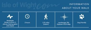
St Catherines Down and Knowles Farm – 2.75 Miles
The Walk
Start at the car park at end of Old Blackgang Road, grid ref: SZ494758
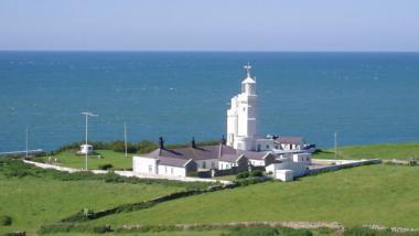
From the car park, walk through the furthest kissing gate and turn left along a grassy track, keeping level and then bearing right. Walk along the top of the ridge and descend steeply to a fence straight ahead. Follow a steep, rough path downhill, with a fence on your right. Cross the stile at the bottom and follow the grassy path straight ahead. This soon bends leftwards, parallel to the sea. The lighthouse will come into view ahead. Cross a stile and follow the path in the direction of the lighthouse. Turn left at the white boundary wall and follow the wall to a gate. Go through the gate and turn left up the road.
After 110yds (100m) go through a gate on the right flanked by stone pillars, sign-posted NT40 to Castlehaven Lane. Keep to the top of the field with the hedge on your left, then cross through a gap in the fence, continuing in the same direction. The path rises gently and goes through a kissing gate on the left after which the path bends right.
After 25yds (25m) the path emerges onto a road. Continue uphill and after 20yds (20m) turn left up a tarmac path with steps and handrail. You will come to a road almost opposite the Buddle Inn. Turn right onto the road for 45yds (40m) before turning left up a tarmac path, by the phone box. Take the path upwards.
Turn right onto another road (watch out for traffic as there is no pavement) and at its end at a Y junction, fork right. Cross the busy A3055 main road to a grassy area and follow the footpath on its right up Barrack Shute towards Niton village. Take the first turn on the left (which looks like a driveway but is Boxers Lane) and follow the path gently upwards to a kissing gate. Go straight on and follow the grassy coast path along the top of the cliffs.
Turn left at the signpost pointing down the steep cliff just before a seat, and descend the steep steps to the road, taking care since these can be slippery. At the road, turn right and follow it back to the car park.

Getting there:
- By foot: This trail follows the Isle of Wight coastal path between Niton and point 5 on the map
- By bike: Sustrans ‘Round the Island’ regional route 67 passes along the A3055 and through Niton
- By bus: Southern Vectis (tel: 01983 827000) No. 6 service from Newport to Ventnor passes through Niton.
- By car: National Trust car park on the old Blackgang Road, a minor road now a cul-de-sac near St Catherine’s lighthouse off the A3055 in Niton undercliff
Walk devised by The National Trust